Day 1
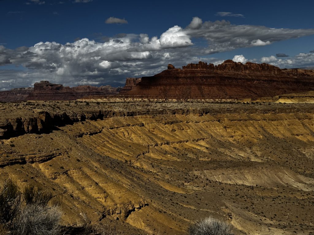
Kicked off today from Spanish Fork, UT, hopping on US-6 east for a solid 6-hour, 318-mile haul to Moab. The route hugs the Wasatch Front’s foothills before blasting into the wild San Rafael Swell – a massive 75×40-mile anticline shoved up 50 million years ago by Rocky Mountain tectonics. It’s basically Utah’s underrated badlands with colorful sandstones, shales, and limestones from ancient seas, eroded into slots, reefs, and hoodoos over eons.
Topography shifts quick – flat valleys to steep canyons, with I-70 slicing through like a knife.
First stop: the ghost town of Thistle.
In April 1983, a massive earthflow – triggered by record snowmelt and rain – buried the town under 10 million cubic yards of mud, damming the Spanish Fork River and creating a 3-mile-long, 200-ft-deep lake that flooded everything. By then, only about 50 residents remained in 22 homes. Rail crews spotted the slide early, issuing evacuations on April 12. Folks grabbed what they could and bailed – no deaths, but they lost homes, heirlooms, and a century-old rail hub.
Downstream in Spanish Fork, 15,000 people prepped for a potential dam breach (engineers gave them 30-45 minutes warning if it went), but a $10 million tunnel rerouted the river in time. Turned into the costliest U.S. landslide ever, sparking Utah’s first presidential disaster declaration. Now it’s just eerie ruins peeking from the water and a quick detour off US-191.
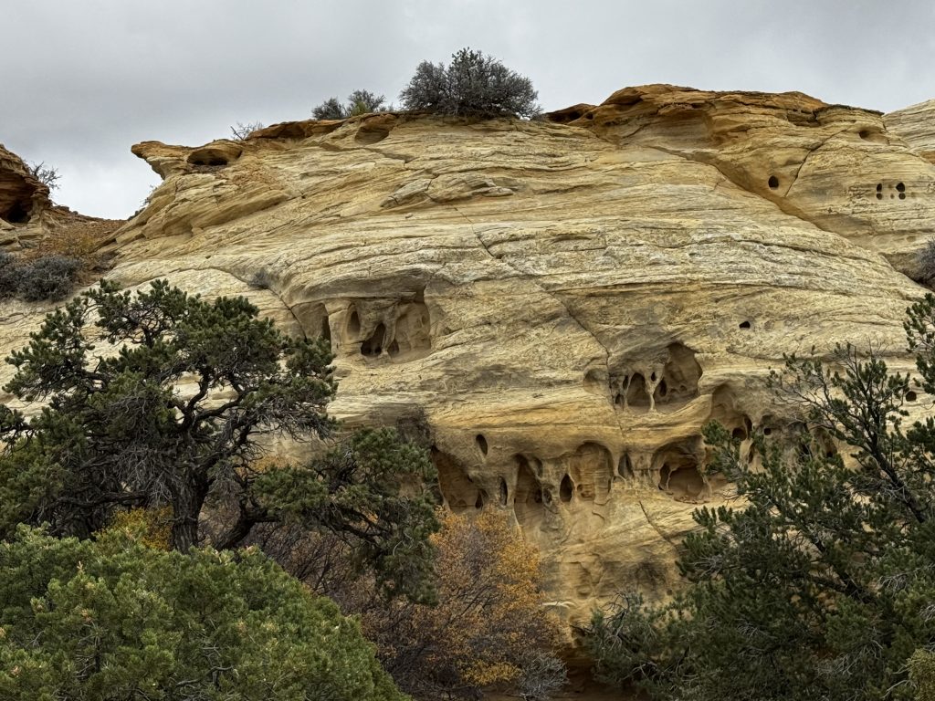
We rolled into Ghost Rock View around mile 123 on I-70. Named for a foggy cowboy sighting of its ghostly Navajo sandstone pinnacle, it’s a prime pull-off for 360-degree vistas of the Swell.
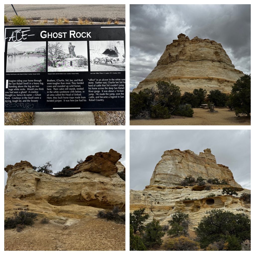
Hike the short sandy loop (watch for snakes and rattlesnakes), picnic under the rock, or just gawk at Eagle Canyon below. Tip: BYOTP (bring your own toilet paper) – rest area and state park pit stops are beyond basic, and it’s super windy so bring a jacket.
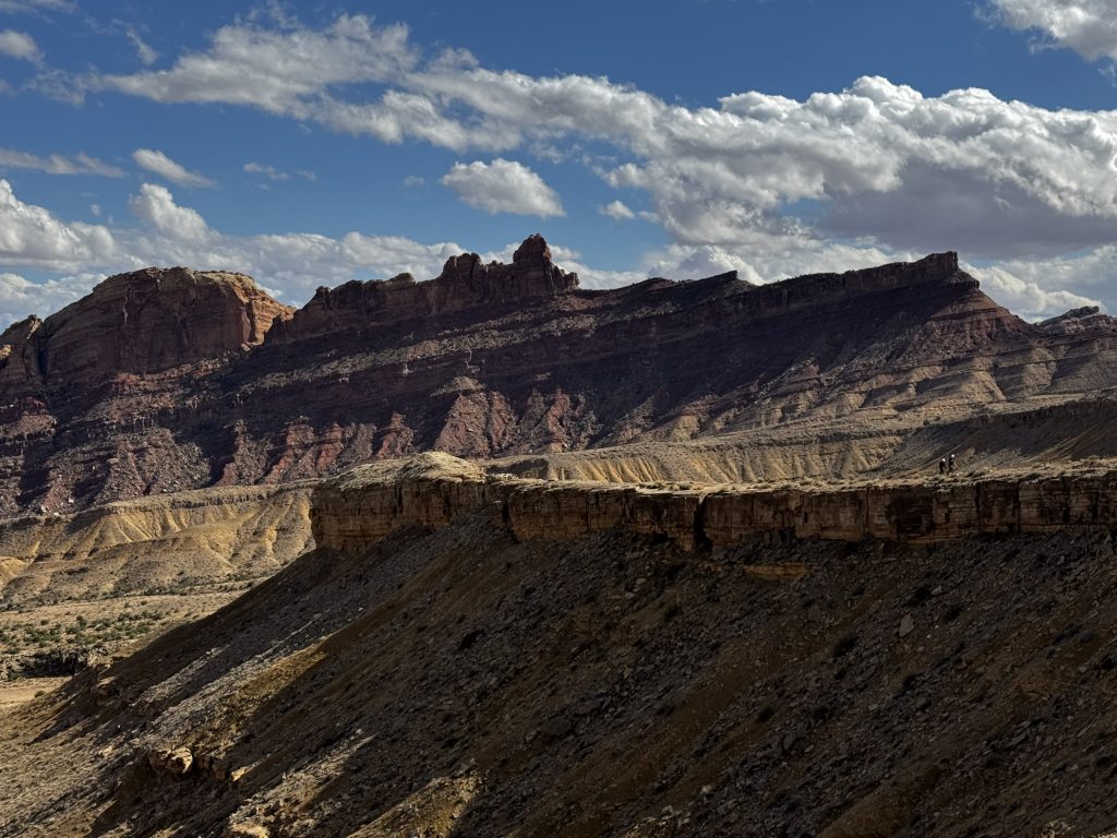
Next, San Rafael Swell proper. This 1,500-sq-mile dome’s eastern edge (the Reef) is a vertical wall of Jurassic layers, full of Fremont and Ute petroglyphs from 1,000+ years ago. Fact: Dinosaurs roamed here; Cleveland-Lloyd Quarry nearby has the world’s densest Allosaurus bones. Scenic spots like The Wedge overlook the “Little Grand Canyon” – a 1,000-ft-deep San Rafael River gash. Hike Buckhorn Draw for cliff-walled washes and ancient Barrier Canyon pictographs (2,000 years old). Pro tip: Very spotty cell service, so download maps in advance; flash floods hit hard in slots – check weather upstream.
Hit Spotted Wolf Canyon View next. One of I-70’s engineering feats – crews blasted 3.5 million cubic yards of rock in the ’60s to thread the highway through this narrow slot.
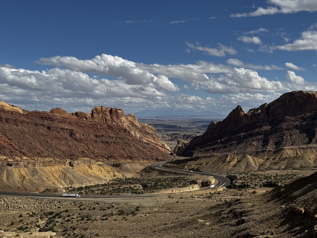
Pull over for overlooks of the Reef dropping to Green River plains. It is the last big vista before the flats. Short trail to the edge, but sheer drops mean no kids off-leash. Fun fact: Pre-highway, cowboys rappelled these walls on ropes.
Shafer Canyon
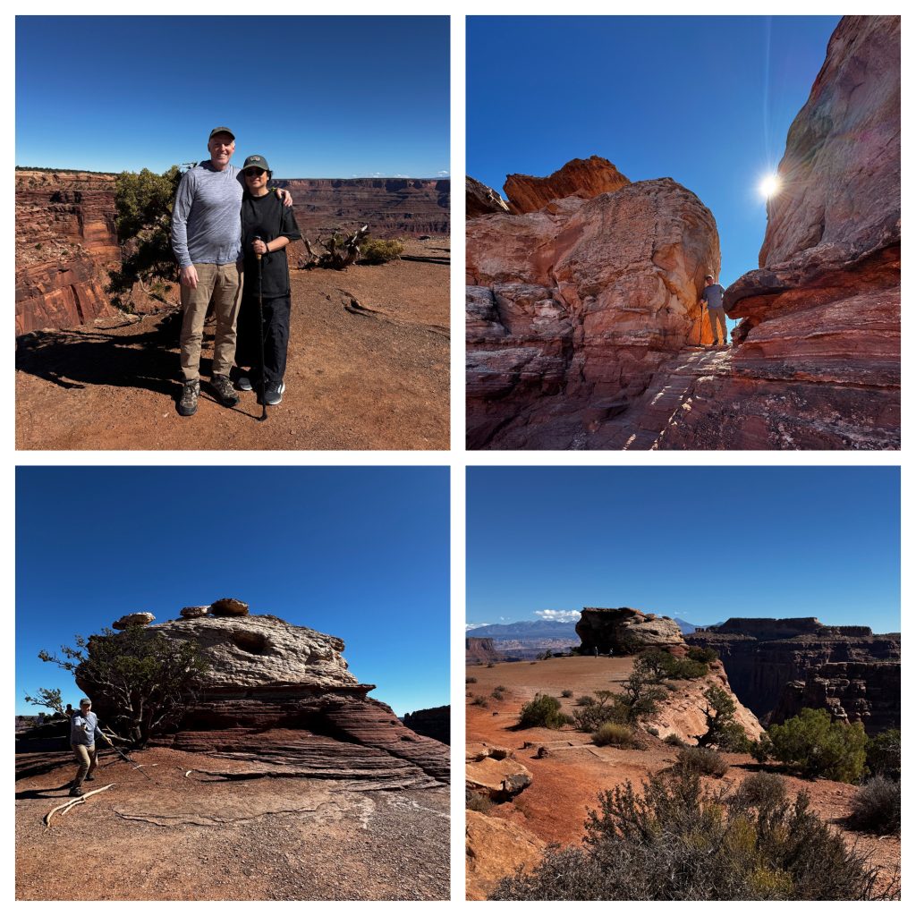
Shafer Canyon Overlook (0.2-mile walk) showed off the switchback trail below, dug by uranium miners in the 1950s, but the canyon’s name honors John Shafer, a cowboy who ran cattle here in the late 1800s.
Detoured off-road to San Rafael Swell, putting the car into off-road mode to get through the muddy farm roads running through cattle fields – a moderate 3.6-mile wash through the Reef’s soft sandstone. Highlight?
Spotted a herd of pronghorn scaling a mountain like it was nothing – those 40-60 mph speedsters handled the steep 400-500 ft climb with ease, a wild sight against the eroded benches. Zero crowds, wild burros too. Wear sturdy shoes – sand’s deep, and no water sources.
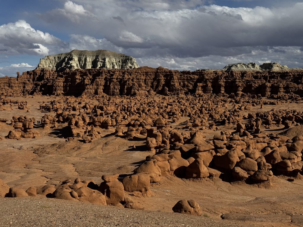
Wrapped up the trip with Goblin Valley State Park, 50 miles south on UT-24 but well worth the detour. Discovered in the 1920s by ferry operator Arthur Chaffin scouting routes; protected in ’54 after vandalism fears, opened as a park in ’64.
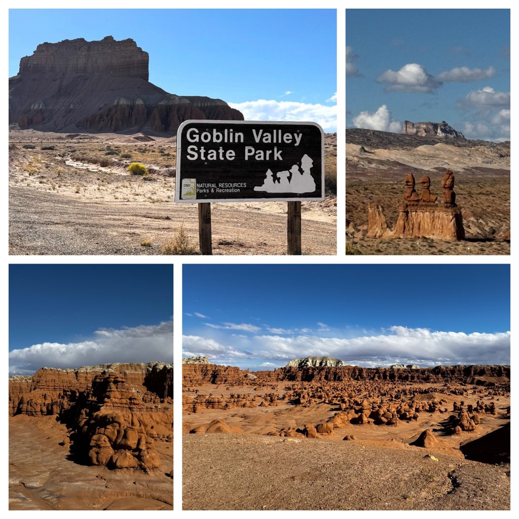
These 170-million-year-old Entrada hoodoos (mushroom rocks) eroded from tidal-flat sands – wind and water carved softer layers faster, leaving 10,000+ “goblins” like a Mars set (filmed in Galaxy Quest). Hike the unmarked valleys (off-trail OK, 6 miles total), hit Observation Point for panoramas, or scramble to Goblin’s Lair cave.
This is an International Dark Sky spot – stargaze like crazy, no light pollution around to mess up the visibility. Entry $20/vehicle; camp on-site (no hookups, book ahead, it was fully booked up today). From there we drove on to Moab, gotta get some rest before heading out to Arches National Park tomorrow.
Day 2
We kicked off from Moab for a solid day trip around Arches National Park, covering about 150 miles round-trip with a mix of driving and hiking.
We started at Mesa Arch, then on to Grand View Point, Shafer Canyon, Dead Horse Point, lunch, The Windows, Balanced Rock, and wrapping up with a sunset hike split between Delicate Arch and the Scenic Viewpoint. Total time was around 10hours, and it was a fun grind with awesome sights, despite the tired legs.
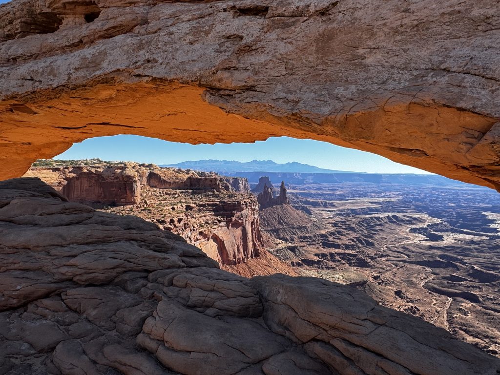
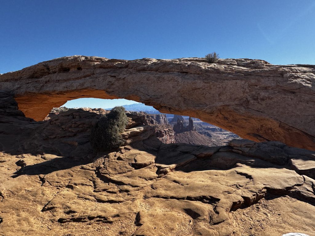
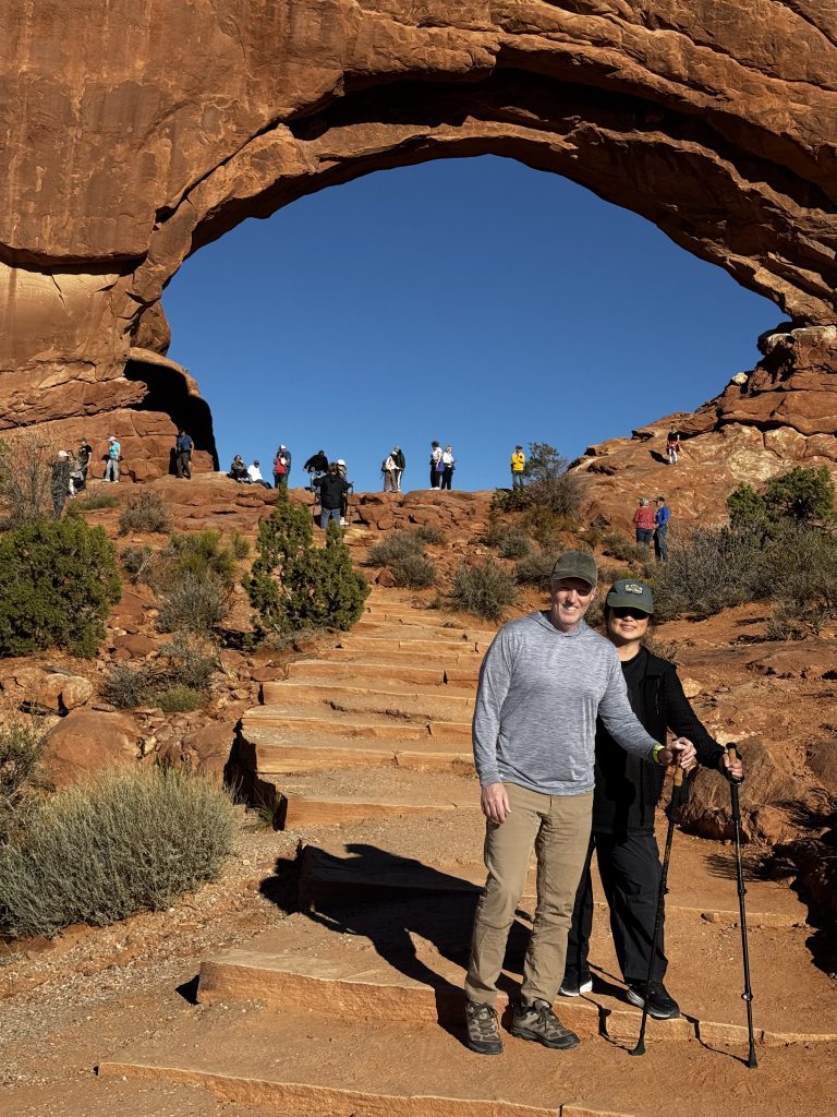
Mesa Arch

Morning Start – We grabbed breakfast at our hotel and then headed straight to Mesa Arch. The 20-mile drive west on UT-313 took about an hour, and the 1-mile hike was moderate with slick rock. That arch framed a sweet canyon view—geologists say it’s 300 million years old, formed from ancient seabed shifts. Caught some ravens soaring around, great morning light for pics. The name “Mesa Arch” comes from the flat-topped mesa it sits on, a term Spanish explorers used in the 1700s for table-like landforms. “Arches” got its name in the 1920s when locals pushed for a national monument, highlighting the natural stone spans.
Grand View Point
Midday Highlights – we hit Grand View Point (10 miles further) with a 1,000-ft drop to the canyon floor—red rock and shrubs popped. We stayed back from the edge, until some wind knocked off one of our hats and we had to latch our walking poles together and hang over the edge to retrieve it. That was more adrenaline than we needed for the day! The Grand View name ties to early 20th-century surveys offering “grand views” of the rugged terrain.
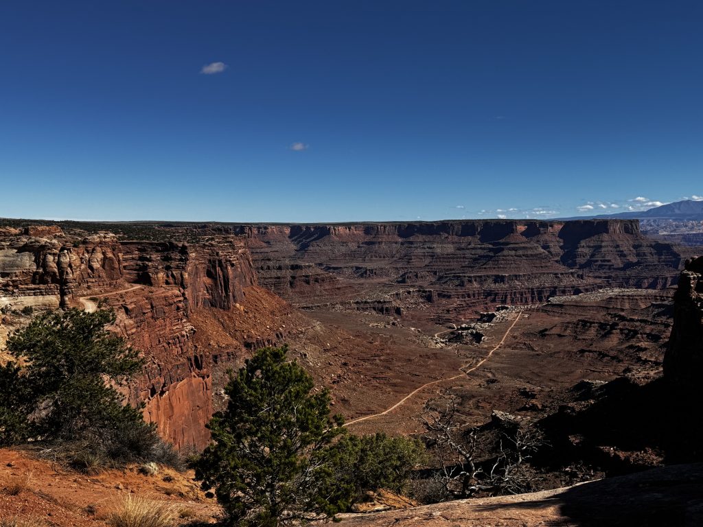
Dead Horse Point
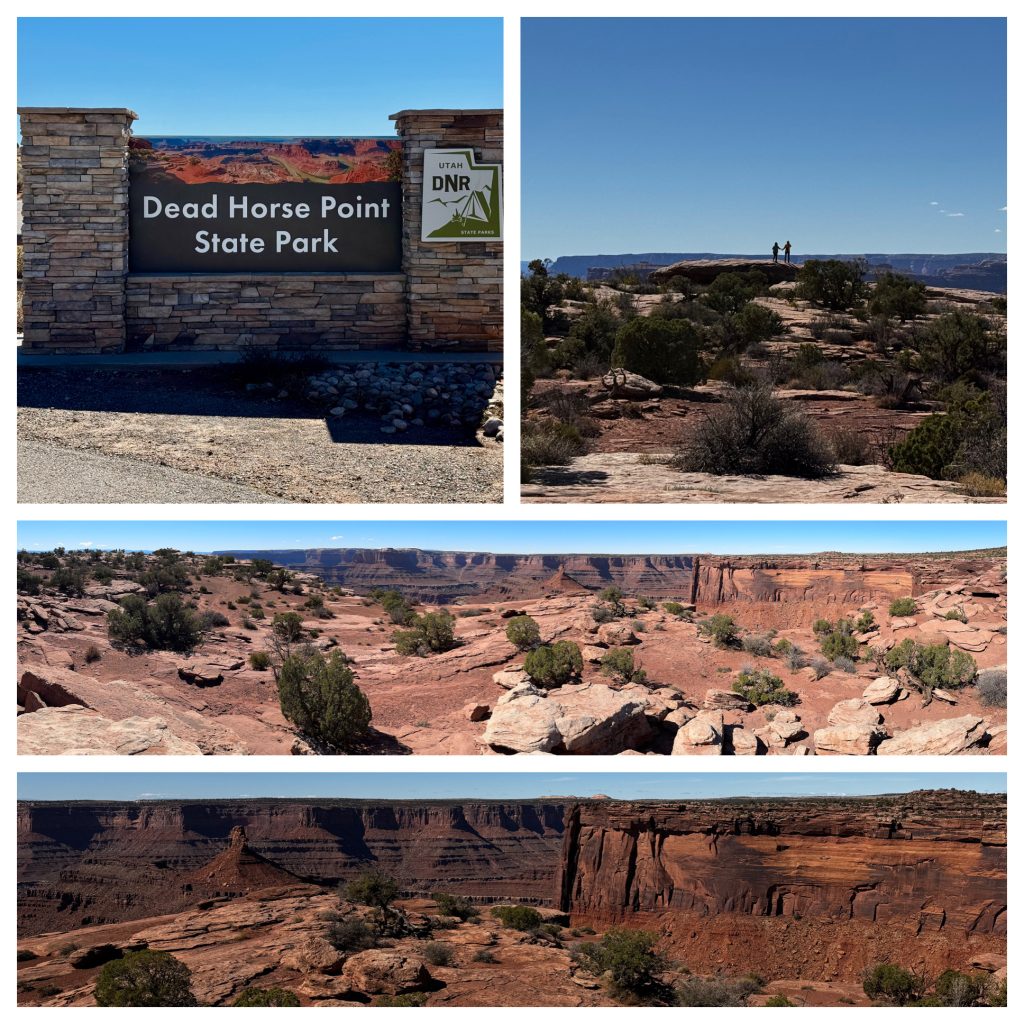
Then we rolled to Dead Horse Point (15 miles west), a 2,000-ft cliff over the Colorado River—Ute tribes trapped horses here in the 1700s, giving it the grim name after a herd reportedly died of thirst. Canyonlands cowboys, like the Shafer family, used these cliffs for grazing until the park was established in 1971.
Lunch Break – After Dead Horse Point, we grabbed lunch in Moab (Moab Garage Co. —food was just ok, though they definitely nailed the tourist prices). Fueled up and kept moving. “Moab” itself comes from a biblical reference settlers used in the 1870s, linking it to the land east of the Jordan River, though it’s more famous now for uranium booms and outdoor vibes.
Arches National Park
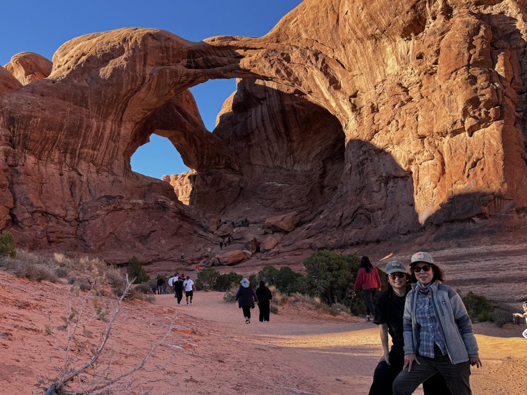
Afternoon Loop – Next was into Arches National Park for the Windows Section (20 miles) including a 1-mile hike to North and South Windows and Turret Arch—those 100-million-year-old eroded sandstone arches looked like giant windows, perfect for goofy shots. The “Windows” name popped up in the 1930s when rangers noted their shape, while “Turret” nods to a castle-like tower nearby.
Window Section
Double Arch
Then we hiked the other side of the stop to see Double Arch, which was great. Balanced Rock, a 128-ft wobbly boulder, was a quick 0.3-mile loop—geologists warn it might tumble. Its name came from early settlers marveling at its precarious balance, a natural wonder since the park’s 1929 monument days.
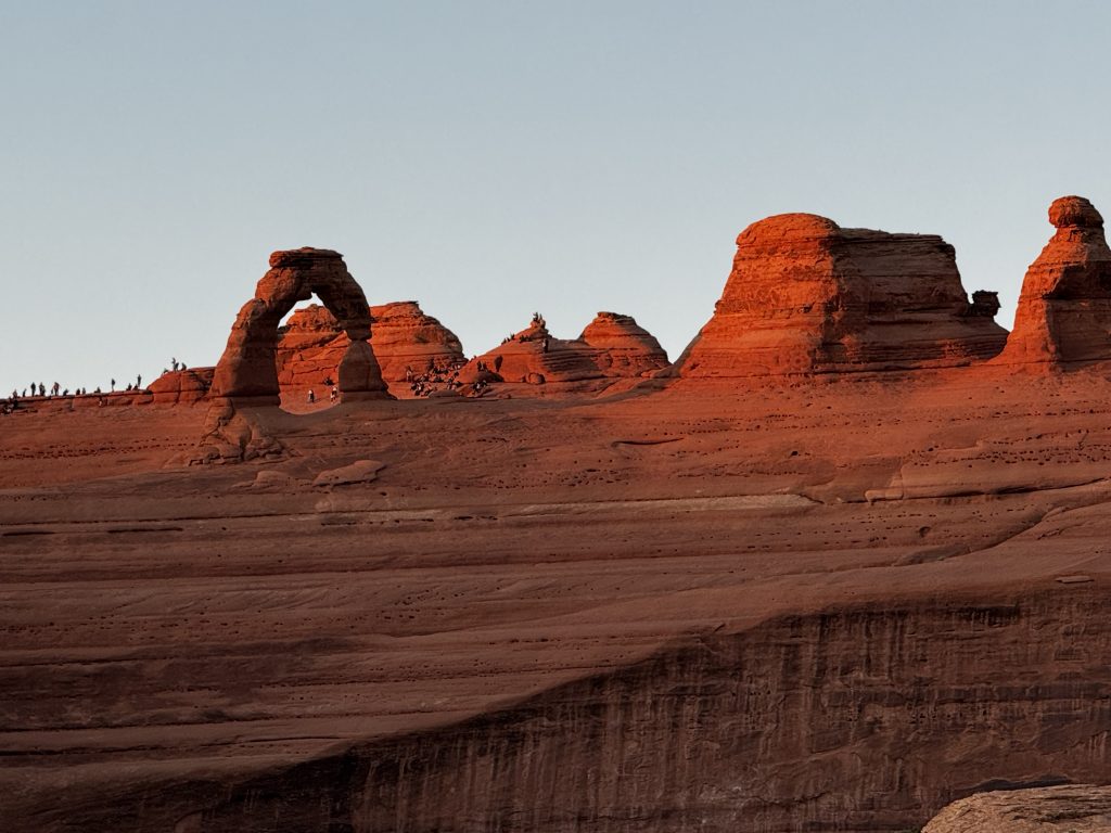
Delicate Arch
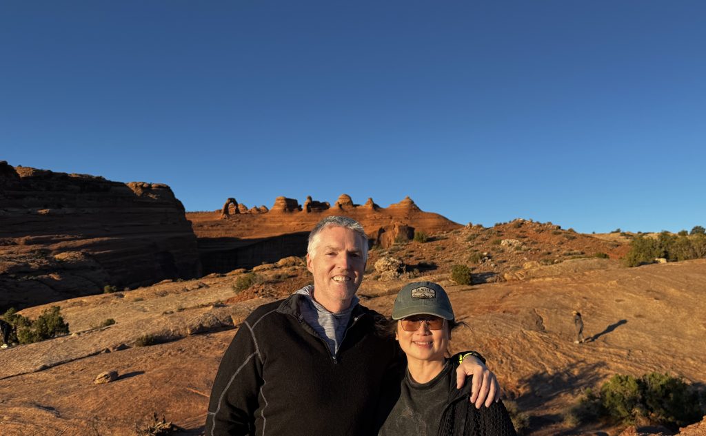
Sunset Hike Split – The big finish was a hike to Delicate Arch for sunset. Half our group tackled the 3-mile round-trip trail (moderate, 480-ft gain, 1.5-2 hours)—that 65-foot arch stands solo against the La Sal Mountains, a real stunner. The other half did the 1.5-mile Scenic Viewpoint trail (easier, 0.5-1 hour) for a distant shot. Sun dipped at 6:45 PM, turning the red rock gold—a little chilly at 5,653 ft, but the views were worth it (although the group that hiked to the arch said the hike wasn’t worth the view and they would do the viewpoint hike next time.
“Delicate” was coined in the 1930s by a park superintendent noting its fragile look, though it’s stood for eons. Cowboys in the 1800s used it as a landmark, and it’s been a photo fave since the 1940s. The La Sal range name comes from Spanish for “The Salt,” tied to early salt trade routes.
Wrap-Up – Drove back to Moab by 7 PM, grabbed instant ramen at a local market, poured in our boiling water and crashed.
The topography through the day shifted from flat desert to jagged canyons, with sagebrush and lizards keeping it wild. Fun fact: Arches has over 2,000 natural arches, more than anywhere else—Delicate’s the star. Tired but worth it—next time, we’re bringing headlamps for that sunset hike!
Day 3
Road Trippin’ from Moab to St. George
A Quick October Dash Through Utah’s Backcountry
Hey folks, it’s October 17, 2025, and we just knocked out a solid day trip from Moab down to St. George—about 300 miles of Utah’s wild side, clocking in around 6 hours of driving with stops.
Left Moab around 10 AM after grabbing breakfast. Trip filled with dusty reds, high plateaus, and crisp fall air where the aspens are starting to turn gold. No frills, just good roads and amazing views.
Here’s the rundown.
Started in Moab, that dusty hub smack in the Colorado Plateau—think 4,000-foot elevation with red sandstone fins everywhere from ancient seabeds that dried up 300 million years ago. The geography here’s all about erosion carving up the Entrada Sandstone into those iconic arches and spires.
Fun fact – Moab’s uranium boom in the 1950s turned it into a ghost town vibe until Arches NP put it on the map.
Hopped on UT-191 south for a quick peek at the La Sal Mountains looming east—12,000-foot peaks of granite and shale, snow-dusted already, formed from volcanic intrusions way back.
Quick pivot west on I-70 through the San Rafael Swell, a massive anticline buckle in the earth’s crust from the Laramide Orogeny (that’s the mountain-building smash-up 70 million years ago). The topography flips fast, narrow canyons with sheer 1,000-foot walls dropping into the Sevier Valley, all layered in gray shales and limestones from prehistoric lakes.
Pulled over at a random overlook near Salina—flat farmlands at 5,000 feet, ringed by the Wasatch Plateau’s pine-covered slopes.
And just happened to get caught in the middle of a cattle drive!
Geography lesson – This area is part of the Great Basin, where rivers don’t make it to the sea; they just sink into the dirt.
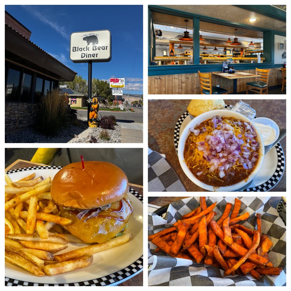
Rolled into Richfield around noon for lunch at Black Bear Diner on S Main Street. Solid spot, decked out with bear carvings on ATVs nodding to Utah’s off-road scene (Richfield hosts the world’s third-biggest ATV jamboree). Grabbed the chili and some chowder, huge portions, breakfast-all-day menu if you’re into that.
Service was quick, no wait on a Friday, and it hit the spot after the morning drive. Pro tip – Their Grizz burger’s a beast if you’re starving.
Fueled up, pushed south on I-15 through Beaver and Parowan—small Mormon pioneer towns from the 1850s, when settlers diverted the Sevier River for irrigation in this high-desert basin (elevation ~6,000 feet).
History hit – Brigham Young sent folks here to farm and fort up against Native raids. Cove Fort nearby is a preserved 1860s stagecoach stop, all adobe and wagon ruts. The drive’s mostly flat valleys hemmed by the Tushar Mountains west (volcanic leftovers) and Markagunt Plateau east, with piñon-juniper scrub giving way to open sagebrush.
Detoured east on UT-14 around 2 PM for a 20-mile climb into Cedar Breaks National Monument. Topography’s nuts—amphitheater of pink cliffs plunging 2,000 feet, carved from the same Claron Formation as Bryce Canyon’s hoodoos.
At 10,000 feet, it’s alpine meadows mixed with subalpine forests of fir and spruce, a total shift from the desert. Quick stop at the rim viewpoint, super Windy, but you get panoramas of Zion’s monoliths 30 miles south.
Fact – Cedar Breaks sits on the Colorado Plateau’s edge, where uplift from the Basin and Range faulting (stretching the crust like taffy) created these escarpments.
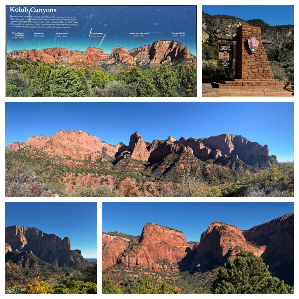
Dropped back to I-15, then veered into Kolob Canyons—the quieter northwest arm of Zion NP. Drove the 5-mile scenic road, Crimson Navajo Sandstone fingers slicing through pine forests at 6,000-7,000 feet.
Pulled off at Taylor Creek trailhead for a 10-minute leg-stretch—double-arch bridge over the creek, with side canyons dropping sharp into the Pine Valley Mountains (highest in SW Utah at 10,300 feet, all granitic batholiths from 20-million-year-old intrusions). Apparently Kolob’s “fingers” are monoclinal folds from ancient faults, eroding into slot canyons that funnel flash floods. No crowds mid-afternoon; just a few hikers and mule deer.
Cruised the last stretch on I-15 into St. George by 5 PM—elevation down to 2,800 feet in the Virgin River Valley, where the Mojave Desert creeps in with black lava flows from Snow Canyon.
Utah is a state full of contrasts, from Moab’s slick-rock deserts to these high-country plateaus and back to low-desert scrub. If you’re routing this way, skip the highway drones—UT-14 and Kolob make it memorable without killing the day. Gas up in Cedar City.
We arrived in St. George. Stayed at Kendall and Chris’s beautiful home in Ivin. Dinner at Royal Thai Express. And we visited the St. George LDS Temple visitors center!
Day 4
Just chilling in St. George. We went to Chuck-A-Rama for lunch. Shopped at Seagulls where we got an extremely good deals on their store closing sales. Then went to Albertsons for some groceries.
Dinner at Kitchen Thai Express!
Day 5
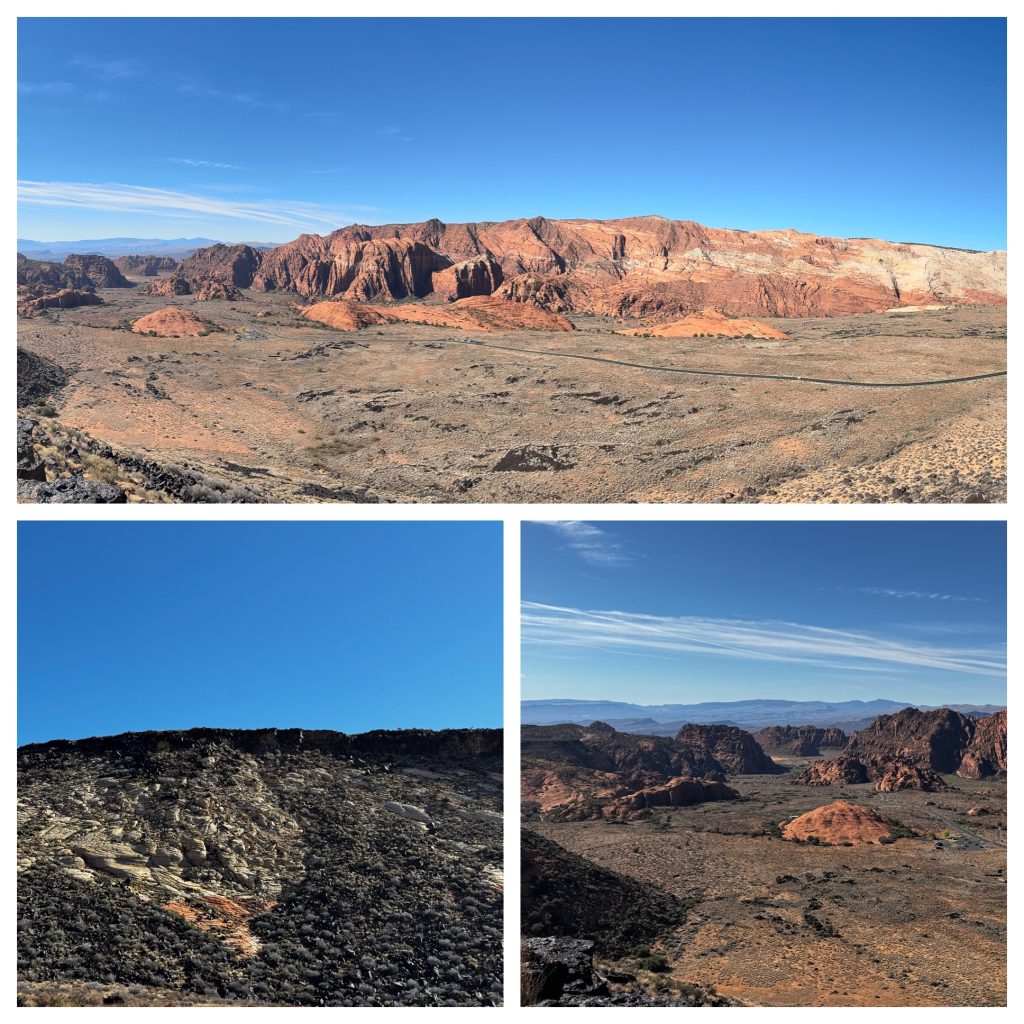
Snow Canyon
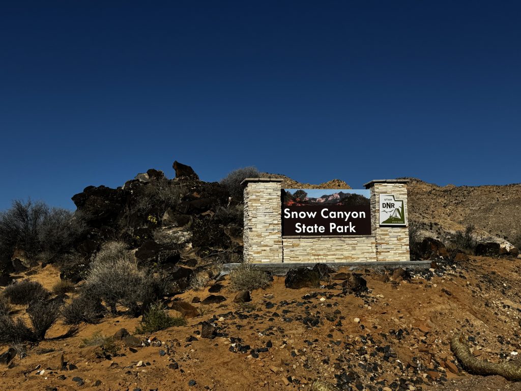
We went to Snow Canyons for some sightseeing. There were lava tubes and similar canyons all around.
We then had lunch at Chili’s. I thought it was good but Kevan didn’t think the food quality was that great!
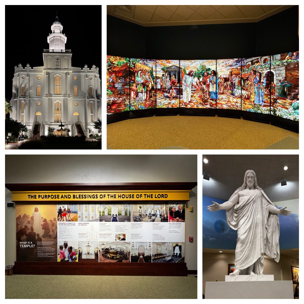
Visiting the St. George Temple Visitor’s Center was amazing. We watched the Plan of Salvation interactive video. Esther was intrigued by the church focus on family happiness. The wall panels with which encompass all the New Testament stories of Chris was fascinating. The sister missionaries told us that the panels were newly additions to the visitor’s center.
Skipped dinner tonight. We watched Nightmare on Elm Street 1983 with Esther and Wang Ge. It was gruesome!
Day 6
Zion Day Trip: Road Trippin’ from Ivins to Epic Canyons
We stayed in Ivins, UT, for our Zion National Park adventure—a sweet base just 45 minutes northeast via I-15 through St. George. Kicked off at 7 AM to beat the crowds and catch the pre-dawn vibes. Zion covers 229 square miles in southwest Utah, where the Colorado Plateau, Great Basin, and Mojave Desert smash together. That mix gives you wild terrain – high plateaus, slot canyons, and mesas carved by the Virgin River over millions of years.
Fun fact – The park’s got 1,500+ plant species and crazy biodiversity for a desert, thanks to elevations from 3,600 to 8,700 feet.
Driving through St. George in the early morning dark, the two LDS temples lit up like beacons—a total highlight. The St. George Temple, dedicated in 1877, is Utah’s first and the oldest still operating, built by pioneers blasting volcanic rock for its base on swampy ground. It’s a sturdy white sandstone fortress (plastered over red rock) with Gothic charm.
The newer Red Cliffs Temple (dedicated in March 2024) sits a little ways away, all sleek and modern—both temples glowing bright white against the black sky, like they were showing off for us. It’s a cool nod to the Mormon settlers who turned this area into “Utah’s Dixie” for cotton farming in the 1800s.
Hit the Zion Visitor Center by 8 AM and grabbed maps. No entry fees since the government is still shut down, and our annual pass would’ve covered the usual $35 vehicle fee anyway. Hopped the free shuttle up Zion Canyon (no private cars in peak season—keeps things smooth).
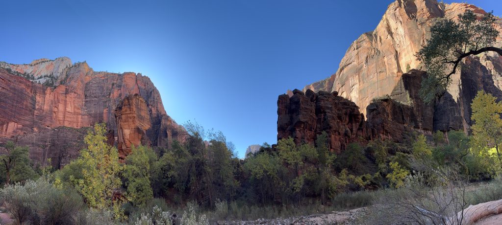
First stop – Temple of Sinawava, shuttle stop #9.
Riverside Walk
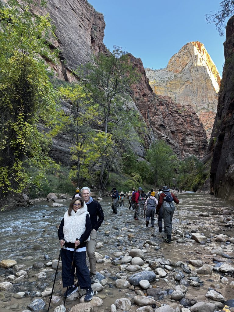
The Riverside Walk is a beautiful 2-mile round-trip path along the Virgin River. Canyon walls close in tight, with hanging gardens dripping from seeps and ferns everywhere. It ends at the Narrows entrance, where the river becomes the trail. The water was a crisp 50°F, staring up at 1,000-foot Navajo sandstone cliffs formed from ancient sand dunes 180 million years ago. Zion is part of the “Grand Staircase” of uplifted layers tying it to Bryce and the Grand Canyon. If you’re not up for the full 16-mile Narrows trek, this is a perfect hike to see the narrows without needing gear.
We then shuttled to Zion Lodge for lunch at Red Rock Grill. Grabbed burgers and grilled cheese sandwiches with killer canyon views, including three massive buttes named the “Patriarchs”. These towering sandstone buttes were named after biblical figures (Abraham, Isaac, Jacob) by a Methodist minister in the 1900s. They tower 1,000 feet, glowing red, with The Sentinel backing them up. They were named in 1916 when the park was young (started as Mukuntuweap National Monument in 1909, full park status 1919).
Red Rock grill food was solid—salads, sandwiches, $15-25 a plate. Reviews mention spotty wait times, but there was a crowd coming in right when they opened for lunch at 1130 and they handled us quick, portions were hefty, and it was a very relaxed lunch spot —way better than a packed lunch.
I bought a couple of cute magnets at the gift shop. The lodge is a good place for a potty break with clean restrooms. Soaking up the sun outside was simply enjoyable and relaxing.
Capped the day driving down the mountain for beautiful views, great day, covered a bunch of trails, no major sweat, just pure scenery. Zion’s got 10,000+ years of Native history (Paiute, Anasazi), plus Mormon pioneers farming the canyon in the 1860s (Isaac Behunin named it “Zion” from the Bible). It’s Utah’s busiest park now (5 million visitors a year), but the shuttle system keeps it manageable and Fall is the perfect time to visit.
Back in St George for dinner and sunset. One day, done right—early start was key. Simply beautiful. We had dinner at Genki Ramen, it was just okay.
Day 6
We left St. George at 8am headed to the Antelop Canyon for a 11:30am guided tour in the Lower Antelope Canyon.
Road Trip Adventure – Ivins, UT to Williams, AZ with a Zion and Grand Canyon Twist
We set out from Ivins, UT, to continue our trip by heading to the Grand Canyon. The drive spans about 380 miles, about 7 hours of drive time, but we stretched it into a full day with detours. Starting at 8:00 AM, we gained an hour crossing into Arizona’s Mountain Standard Time (no daylight saving), so our trip adjusted accordingly. Our route headed North through St. George, then East on Hwy 389 until dipping into Arizona via US-89A. We diverted past Page to make sure we hit Lower Antelope Canyon, with stops at Jacob Lake and Desert View Watchtower, before reaching Williams.
Geographically, we crossed the Colorado Plateau, a high desert plateau stretching across Utah, Arizona, and Colorado, shaped by ancient rivers and tectonic shifts into eroded landscapes. Elevations range from 3,000 feet near St. George to 6,800 feet in Williams, moving through red rock country and pine forests. Historically, this area has been home to Ancestral Puebloans and Paiute for thousands of years, with Mormon settlers arriving in St. George in the 1860s for cotton farming, and Route 66 later turning Williams into a nostalgic stopover.
First stop – Jacob Lake, about 2 hours from Ivins, we were stopping to grab some Indian fry bread at the Jacob Lake Inn, his spot sits at 8,000 feet, near the Kaibab Plateau, and it was reputed to have Paiute fry bread, warm, crispy fry bread—topped with either honey/cinnamon or beans and cheese—would have been a perfect fuel-up, but the fry bread cook was out so we missed out. We wanted to do this because Kevan’s Mom made the best fry bread and we wanted to compare it. But the Inn was a great stop, it’s a historic roadside joint, famous for its bakery and as a gateway to the North Rim, with a cozy vibe and great views of the surrounding pines. The area itself—named for the small, often-dry pond called Jacob Lake—honors Jacob Hamblin, a prominent Mormon missionary and explorer known as the “Buckskin Missionary” or “Apostle to the Indians.”
Hamblin (1819–1886), an early convert to The Church of Jesus Christ of Latter-day Saints (LDS Church), played a key role in southern Utah and northern Arizona settlements starting in the 1850s. He scouted routes for Mormon pioneers, negotiated peace with Paiute and Navajo tribes, and helped establish missions like Pipe Spring in 1863. The Paiute reportedly named the lake after him during his travels along what became the “Honeymoon Trail”—a wagon route from southern Utah to St. George for temple weddings. Before the inn, the site was a vital water stop on Paiute migration paths that Hamblin and other Mormons expanded into wagon roads in the late 1800s.
Lower Antelope Canyon
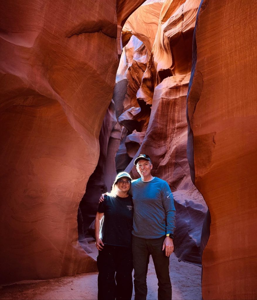
Next up – Lower Antelope Canyon near Page, AZ, about 1.5 hours from Jacob Lake, hitting it around 11:30 AM. We had booked a 90 minute tour with Ken’s Tours (next time we will book directly with Kens Tours online, it is cheaper than going through an online reseller – we paid nearly $100 but the direct rate was around $75, live and learn).
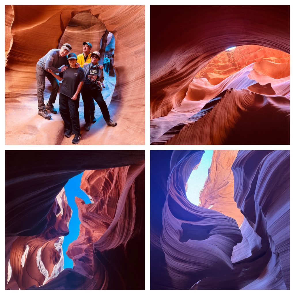
The collage includes pictures resemble a nice sunset, a sea horse, and the face of a lady with her hair blowing in the wind!
The slot canyon features stunning swirls of red and orange sandstone, carved by flash floods over centuries. Guides highlighted beautiful light beams and shared Navajo stories tied to their ancestral land. The walk is easy but some of the metal staircases up/down are pretty steep and some of the canyons get a little tight, but it’s an enchanting place for capturing photos of those wavy walls that resemble nature’s artwork. A definite highlight, even with a few other tourists navigating for shots.
Dessert View Watchtower
Continued to Desert View Watchtower, about 2.5 hours from Lower Antelope, along the South Rim’s East Entrance, arriving around 3:00 PM.
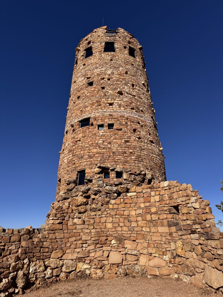
This 70-foot stone tower, designed by Mary Colter in 1932, offers a panoramic view of the Grand Canyon’s eastern expanse—over 1,000 feet down to the Colorado River. Built with local rock to blend into the landscape, it’s a cool nod to Ancestral Puebloan architecture and a perfect photo op before heading deeper into the park. They also have great ice cream cones at the gift shop there!
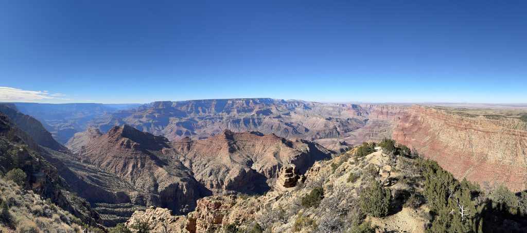
Yavapai Point
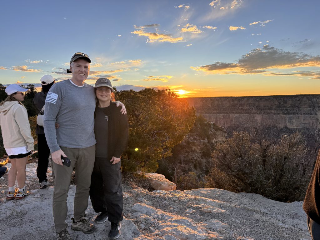
Pushed on to the Grand Canyon’s South Rim—about 60 miles from Flagstaff—arriving late afternoon. Caught a gorgeous sunset at Yavapai Point, with the canyon’s layers glowing red and orange as the sun dipped around 6:45 PM.
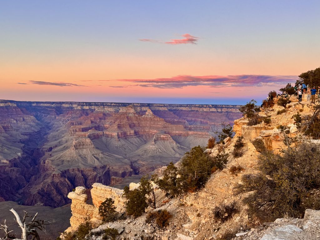
The Grand Canyon’s 277 miles long, formed by the Colorado River over 6 million years, and its South Rim sits at 7,000 feet, offering those jaw-dropping views.
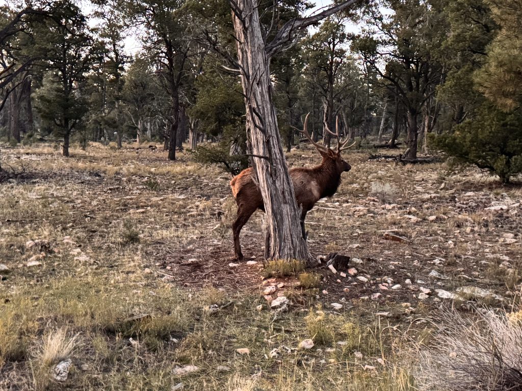
As we drove South toward Williams, huge elk were literally right beside our car—we stopped to chat and snap photos, marveling at their 4-foot-wide antlers up close.
Back on the road, we made it to the Trailborn Grand Canyon hotel just in time for dinner at Miss Kitty’s Steakhouse, which closes at 8:00 PM. The meal was pretty decent—steak and sides hit the spot for $20-30—exhausted but happy.
This trip mixed history, geography, and natural beauty—Zion’s canyons, Antelope’s slots, and the Grand Canyon’s vastness, along with some great wildlife. Perfect day with an early start and great stops. Tomorrow it’s on to a completely different type of sightseeing – Las Vegas!